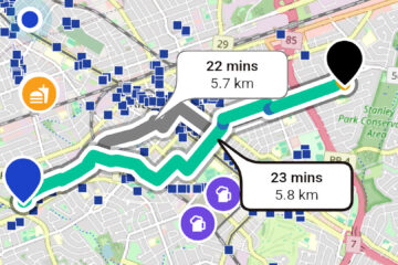
News

Three children on bikes are cycling away from the viewer on an asphalt multi-use path. Grass and trees are visible on either side of the path.

What problem is Cycling Guide solving?

Weā€™re focussed on enabling cyclists to get from their starting point to their destination using the best available low-stress, cycling-centric routes. We believe that these routes are just whatā€™s needed for people who want to cycle more in their daily lives but lack the experience, knowledge, or confidence to do so comfortably.

A street map shows part of Kitchener and Waterloo. There's a route trace that's mostly green and blue going from top left to bottom right. There are many small blue retables with white bike icons marked on them.

Why Does Cycling Guide Use OpenStreetMap?

OSM is well aligned with one of the goals of Cycling Guide Foundation: to provide a hyperlocal resource for anyone who would like to find their way on a bicycle, no matter what their experience or confidence level. And as we tune Cycling Guideā€™s handling of the OSM data, the app is generating fantastic routes that, wherever possible, avoid the need to travel with heavy traffic.